Research Article | | Peer-Reviewed

Mapping Health Disparities: Spatial Accessibility to Healthcare Facilities in a Rural District of Ghana Using Geographic Information Systems Techniques

Received: 4 August 2024     Accepted: 24 August 2024     Published: 6 September 2024
Views:       Downloads:
Abstract

Background: Access to healthcare is crucial for health equity and outcomes, especially in resource-limited rural areas. Despite expansion efforts, access disparities persist, impacting rural well-being. Assessing spatial accessibility to primary and secondary healthcare is essential for identifying underserved areas and guiding effective resource allocation and intervention strategies. Objective: This study aims to evaluate the geographic access to healthcare services in a rural district of Ghana using Geographic Information Systems (GIS) and spatial analysis techniques. Methods: Utilizing Geographic Information Systems (GIS) 3.28.6, spatial data including health facility locations, settlements, road networks, and population data were analysed. Buffer and distance to the nearest hub analyses were conducted to assess healthcare accessibility to all ten (10) healthcare facilities in the district. Travel time analysis was performed using specified travel speeds for various modes of transportation. Chi-square tests were employed to evaluate the associations between settlement characteristics and access to primary and secondary healthcare services. Results: Approximately 40% of the health facilities were located in Akumadan, the district capital. Primary healthcare accessibility within a 3km radius covered 35% of settlements and 59% of the population, while secondary healthcare, within a 5km radius, was accessible to only 11.3% of settlements and 27.2% of the population. The mean distance to health centres was 4.35±2.72 km and to hospitals was 10.35±5.77 km. Mean walking times were 87±54.6 minutes to health centres and 209.2±117.0 minutes to hospitals. By motorized transport, travel times were up to 24 minutes to health centres and 55 minutes to hospitals; by bicycle, up to 37 minutes to health centres and 190 minutes to hospitals. Chi-Square Tests revealed significant associations between settlement type and both primary (χ²(1, N=80) = 30.77, p <.001) and secondary (χ²(1, N=80) = 15.93, p <.001) healthcare access, as well as between population level and healthcare access. Proximity to health facilities (primary χ²(1, N=80) = 21.26, p <.001; secondary χ²(1, N=80) = 5.48, p =.019) and transportation accessibility (primary χ²(1, N=80) = 9.13, p =.003; secondary χ²(1, N=80) = 12.13, p <.001) were significantly associated with healthcare access. Conclusion: This study unveils substantial disparities in healthcare accessibility, characterized by uneven distribution of facilities and remote distances. Challenges include limited infrastructure and geographic isolation. Addressing these requires enhanced infrastructure, transport networks, expanding outreach services, and equitable policy reforms to promote health equity.

Published in American Journal of Health Research (Volume 12, Issue 5)
DOI 10.11648/j.ajhr.20241205.11
Page(s) 110-123
Creative Commons

This is an Open Access article, distributed under the terms of the Creative Commons Attribution 4.0 International License (http://creativecommons.org/licenses/by/4.0/), which permits unrestricted use, distribution and reproduction in any medium or format, provided the original work is properly cited.

Copyright

Copyright © The Author(s), 2024. Published by Science Publishing Group

Keywords

Healthcare Disparities, Primary Healthcare, Secondary Healthcare, Healthcare Access, Spatial Analysis, Outreach Services

1. Introduction
Access to healthcare facilities is a cornerstone of equitable healthcare delivery and improved health outcomes, particularly in rural areas . This access encompasses various facets, including physical proximity to facilities, transportation availability, affordability of services, and cultural acceptability of care. In rural districts, where geographic isolation and limited infrastructure pose significant challenges, ensuring adequate healthcare access becomes even more imperative, as limited access can lead to delayed diagnosis and treatment, resulting in poorer health outcomes and increased morbidity and mortality rates . Healthcare accessibility, defined as the population's ability to obtain a specified set of healthcare services, involves the intricate interplay between population distribution and the availability of healthcare facilities .
Globally, the well-being of populations and spatial accessibility to healthcare facilities are crucial drivers of economic growth and prosperity, prompting governments to ensure equitable and easily accessible healthcare services for all citizens . However, access to reliable healthcare facilities remains a challenge for approximately 1.3 billion people worldwide, particularly in developing countries .
In Ghana, Healthcare expenditure represented 3.54% of the Gross Domestic Product (GDP) in 2018, with fluctuations observed over the years but generally declining since 2004, reaching only 3.5% in 2018. In rural Ghana, the condition of roads significantly affects healthcare access, highlighting challenges in reaching medical facilities . To address these challenges, Ghana has implemented a five-tier health delivery system, including Community-based Health Planning and Services (CHPS), health centres, district hospitals, regional hospitals and teaching hospitals aimed at ensuring decentralized, responsive, and accessible medical care nationwide .
The Offinso North district in Ghana epitomizes the difficulties faced in healthcare access, with numerous settlements located far from the district capital. Despite recent additions to healthcare infrastructure, such as the introduction of a new health facility, accessibility to healthcare services has not significantly improved, primarily due to its proximity to another town already equipped with healthcare facilities. The district grapples with pressing healthcare challenges, evident from an outpatient department (OPD) per capita of 0.83, a skilled delivery rate of 61%, and notable instances of under-five deaths and maternal mortality. Urgent measures are warranted to enhance healthcare access, foster proactive health-seeking behaviour, and address public health issues through comprehensive assessments of accessibility .
Spatial analysis techniques, particularly Geographic Information Systems (GIS), play a pivotal role in identifying and understanding healthcare accessibility disparities by analyzing spatial access and utilization patterns. These techniques enable policymakers to assess the distribution of healthcare facilities relative to population needs and geographical barriers, crucial for effective resource allocation and intervention planning .
While previous studies have utilized GIS to explore healthcare facility access in Ghana , data on geographical accessibility to primary and secondary healthcare considering common transport modes such as walking, cycling, motorcycling, and driving remain limited. Therefore, this study aims to assess spatial accessibility to primary and secondary healthcare facilities in Offinso North, a rural district of Ghana, using prevalent means of transport for travel time estimation from settlements to the nearest health facility. The objectives of this study is to evaluate the geographic access to healthcare services in a rural district of Ghana using Geographic Information Systems (GIS) and spatial analysis techniques.
2. Materials and Methods
2.1. Study Area
The study was carried out in the Offinso North District of Ghana. Established in the latter part of 2007, is among the 43 Administrative Districts within the Ashanti Region, situated in its extreme North-Western part. Spanning a longitude range of 1˚45w to 1˚65w, it shares borders with Techiman, Sunyani Tano, and Nkroanza Districts in the Brong Ahafo Region to the North and West, while being adjacent to Sekyedumase District in the East and Offinso South Municipality in the South. Encompassing approximately 6300 square kilometres, which accounts for about 2.6% of the Ashanti Region's total surface area, the district is intersected by the Accra-Kumasi trunk road, serving as a crucial gateway from the Northern and Brong Ahafo Regions into the Ashanti Region. Akumadan serves as the district capital, with other significant settlements including Nkwakwaa, Asempanaye, Asuosuo, Nkenkaasu, and Afrancho, located along the Kumasi-Techiman Road. The district is divided into five sub-districts: Akomadan, Amponsakrom, Nkenkaasu, Kobreso, and Mankramso. Presently, the estimated population stands at approximately 86,981, exhibiting a growth rate of 2.7%, with an average household size of 6. Predominantly rural, about 78% of the population resides in rural areas. The healthcare infrastructure includes two hospitals, five health centres, and three Community-based Health Planning and Services (CHPS) Compounds.
2.2. Data Collection
Spatial data were obtained from the District Health Directorate and OpenStreetMap, encompassing geospatial coordinates for 10 health facilities, road networks, and 80 settlements as of 2023. It also covers administrative boundaries (sub-district boundaries of the study area) and population data for all 80 settlements and sub-districts. Field visits were conducted to validate the accuracy of health facility spatial data and gather additional information on health facility attributes.
2.3. Data Analysis
The coordinates (latitude and longitude) of health facilities, including hospitals, health centres, Community-Based Health Planning and Services (CHPS) compounds, and settlements, underwent conversion to compatible formats (e.g., CSV, Shapefile) and were projected into a unified coordinate system. The spatial integrity of these datasets was meticulously verified to ensure accurate georeferencing (Geometry CRS at EPSG:4326-WGS84). The visualization of the datasets was conducted using Google Earth Pro version 7.3.2.5776 to confirm both accuracy and spatial distribution. Validation and quality checks were executed for the results obtained from distance analysis, involving comparisons with ground truth data or field observations. Any anomalies or errors identified during the analysis process were thoroughly scrutinized to ensure that the analysis represents the real-world scenario and yields valuable insights.
2.3.1. Buffer Model
To establish service coverage areas, buffer zones were established surrounding each healthcare facility, utilizing the geometry Coordinate Referencing System of EPSG:32630-WGS84/UTM zone 30 N, with a segment of 5 and a milter limit of 2.0 to define varying buffer distances corresponding to different levels of service provision. Following WHO guidelines , a 3km buffer was designated around all health centres and CHPS compounds, while a 5km buffer enveloped all hospitals within the study's catchment boundaries. In this study, settlements situated beyond the 3km buffer were identified as having limited geographic accessibility to primary healthcare, while those outside the 5km buffer were deemed to have constrained access to secondary healthcare .
2.3.2. Distance to Nearest Hubs Model
Central locations (hubs) within the settlement were identified based on population density or administrative significance. The distance from each populated area to the nearest hub was computed to determine access to centralized healthcare resources. Symbology and colour ramps were used to represent distance values effectively. Statistical analysis was done to quantify accessibility metrics. Summary statistics such as mean distance, median distance, and standard deviation were computed on the distance matrices. The closest facility analysis technique was employed to evaluate the closeness of health centres to local hubs. This strategy is pivotal for reducing distances, time, and expenses, particularly in situations requiring prompt medical attention. This method pinpointed the nearest health centre for every community .
2.3.3. Population Coverage Within Facility Buffers
Population coverage within recommended buffer zones was calculated to assess the accessibility of health facilities using the select by location tool with 3km and 5km buffers as the comparing features. Total population coverage accessing health facilities within the recommended buffer radius was calculated using this formula:
(n/N) x 100
Where n = total population of settlements within a 3km or 5km buffer radius, N = total district population.
2.3.4. Travel Time Analysis
Travel times from settlements to health facilities were determined through the application of specified adjusted travel speeds for different transportation modes; Car: 50 km/hr; Motorbike: 30 km/hr ; Bicycle: 20 km/hr ; Walking: 3 km/hr . Adjustments were made to these speeds to accommodate the varied terrain and road conditions prevalent within the study area. Settlements located along the Techiman-Kumasi major road were assigned a speed of 50 km/hr, while other settlements received a speed assignment of 30 km/hr, reflecting the respective transportation infrastructures. Nonetheless, the speed values for motorbikes, bicycles, and walking remained constant across all settlements in this investigation. Distance measurements from hubs derived through Distance to Nearest Hubs analysis were exported as a CSV file. A supplementary field designated as "speed" was added to the CSV dataset using Microsoft Excel, version 2016. Subsequently, employing the predominant mode of transportation within each settlement, the corresponding speed values were applied to the respective settlements within the CSV file. The time required to travel to the nearest health facility was calculated in minutes using the formula Time = Distance / Speed . In instances where the resulting travel time contained a non-zero decimal value, this value was converted into minutes by multiplying it by 60 and added to the hours obtained, thereby providing an approximation of the total travel time. Descriptive statistics, including mean and standard deviation, were computed for travel times utilizing the basic statistics for field tool available in QGIS version 3.28.6.
2.3.5. Inferential Analysis
Chi-square tests of independence were utilized to analyze the relationships between settlement characteristics and access to primary and secondary healthcare services, with a significance level set at 0.05. Settlements were classified into “large” (populations of 1,500 or more) and “small” (populations under 1,500). Population sizes were categorized as “less than 1,000” and “1,000 or above”. Proximity to health facilities was categorized as close (within 3 kilometres) or far (beyond 3 kilometres). Health facility availability was noted as “Yes” (facility present) or “No” (facility absent). Transport accessibility was defined based on whether settlements had continuous access to motorbikes or vehicles, and was categorized as either “Yes” or “No.” The outcome variables included “Access to Primary Healthcare Facilities” and “Access to Secondary Healthcare Facilities,” with coding of “1” indicating access and “0” indicating lack of access.
2.3.6. Data Presentation
The results of the spatial analysis were presented using a combination of maps and tables. Maps depicted the distribution of health facilities, population density, buffer zones, and travel distance contours to visualize spatial patterns. Tables summarized descriptive statistics and key findings, providing a concise overview of the analysis results of the travel time and distance to the nearest health facilities.
3. Results
3.1. Health Facility and Population Distribution in Offinso North District
The highest health facility-to-population ratio (1:19224 per pop) was recorded in the Nkenkaasu sub-district whereas the lowest ratio was observed in the Kobreso sub-district at 1:6044 per pop. Nearly 40% of the health facilities within the district are situated in its capital, Akumadan. Approximately 38% of the health centres and Community-Based Health Planning and Services (CHPS) Compounds are in the Kobreso sub-district (Figure 2).
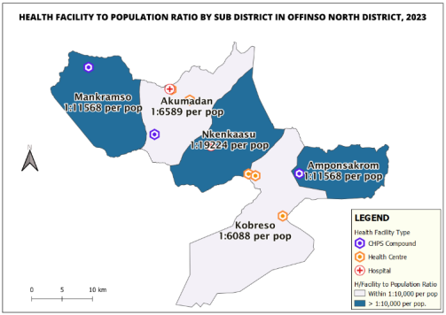
Figure 1. Health Facility to Population Ratio analysis, Offinso North District, 2023.
3.2. Health Facility Accessibility Analysis
A total of 28 settlements, constituting 35% of the total settlement in the district, are situated within a 3km radius of health centres and Community-Based Health Planning and Services (CHPS) compounds. Approximately 9 settlements, accounting for 11.3%, are positioned within a 5km radius of hospitals (Figure 2). Settlements within 3km and 5km in Table 1.
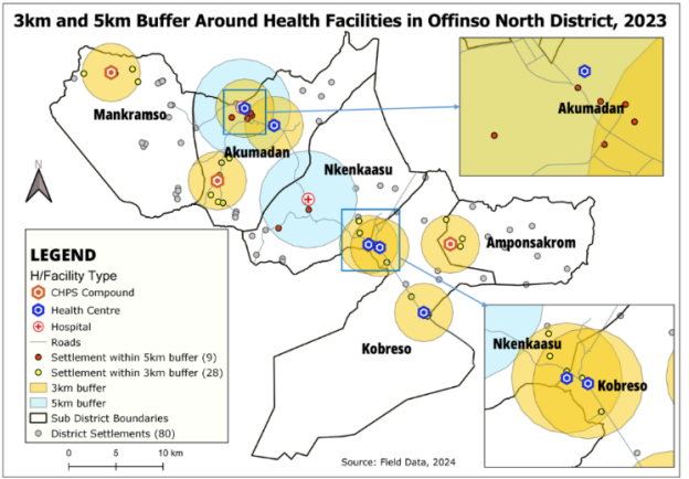
Figure 2. Spatial analysis of health facility spatial accessibility using 3km and 5km buffer, Offinso North District, 2023.
Table 1. Settlements within 3km and 5km buffer in Offinso North District.

List of settlements within 3km buffer zone

List of settlements within 5km buffer zone

Akumadan, Akumadan-Zongo, Amponsakrom, Asempanaye, Asuoso, Bredane, Caanan, Afrancho, Darso, Dwenedabi, Fante, Gyidi, Kobreso, Kobreso-Zongo, Kwaekesiem, Kwaaware, New Atwene, Bosomponso, Nkwaankwaa No. 2, Ampenkrom, Nkwankwaa No. 1, Nsenoafie, Old Atwene, Sraneso-Zongo, Sraneso No.2, Sraneso No.1, Srentiatia, Tadieso, Tanokwaem

Akumadan, Akumadan-Zongo, Bontenten, Caanan Afrancho, Gyidi, New Atwene, Nkenkaasu, Old Atwene

3.3. Health Facility Distance Analysis
Approximately 65% of settlements are located at distances exceeding 3 kilometres from the nearest health centre or Community-based Health Planning and Services (CHPS) Compound, with only 35% falling within this 3-kilometre threshold (Figure 3).
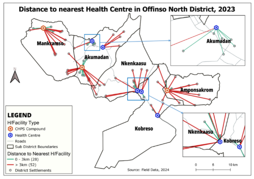
Figure 3. Spatial Analysis of Distance to Nearest Health Centre, Offinso North District, 2023.
Approximately 89% of settlements are situated beyond a distance of 5 kilometres from the nearest hospital, with only 11% falling within this 5-kilometre radius (Figure 4).
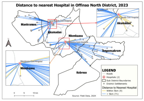
Figure 4. Spatial Analysis of Distance to Nearest Hospital, Offinso North District, 2023.
The furthest distance recorded from a settlement to the nearest health centre was approximately 12 kilometres, with a mean distance of 4.35 (2.72) kilometres. The shortest distance measured was 0.3 kilometres. Regarding the proximity to the nearest hospital, the maximum distance from a settlement was noted as roughly 28 kilometres, while the minimum distance was 0.4 kilometres. the mean distance from settlements to the nearest hospital was 10.35 (5.77) kilometres (Table 2).
Table 2. Descriptive Analysis of Distances to Health Facilities in Offinso North District, 2023.

Variable

Health Centres/CHPS Compound (km)

Hospital (km)

Distance to nearest health facility

Minimum

0.26

0.4

Maximum

12.23

27.5

M (SD)

4.35 (2.72)

10.35 (5.77)

3.4. Travel Time Estimate by Commonest Means of Transport
The maximum time required to travel to the nearest health centre and hospital by foot was recorded as 4 hours 5 minutes and 9 hours 10 minutes, respectively. The mean time for walking to the nearest health centre and hospital was 87.0 (54.6) minutes and 209.2 (117.0) minutes, respectively. When utilizing a car or motorbike, the maximum travel time to the nearest health centre or hospital was observed to be 24 minutes and 55 minutes, respectively. Reaching the nearest health center would require up to 37 minutes, while reaching the nearest hospital would take up to 90 minutes by bicycle. (Table 3).
Table 3. Time travel to nearest health facility analysis, Offinso North District, 2023.

Variable

Health Centre/CHPS Compound

Hospital

Travel time to nearest health facility in minutes

Means of travel

Min

Max

Mean (SD)

Min

Max

Mean (SD)

Walking

5

245

87.0 (54.6)

8

550

209.2 (117.0)

Car

0

24

8.34 (5.46)

0

55

19.87 (11.79)

Motorbike

1

24

8.69 (5.43)

1

55

20.69 (11.52)

Bicycle

1

37

13.05 (8.15)

1

90

34.4 (17.1)

3.5. Determinants of Healthcare Access
A Chi-Square Test of Independence was conducted to evaluate the association between settlement characteristics and access to primary and secondary healthcare services. The results indicated that settlement type was significantly associated with both primary (χ² (1, N=80) = 30.77, p <.001) and secondary (χ² (1, N=80) = 15.93, p <.001) healthcare accessibility. Population-level also showed a significant association with primary (χ² (1, N=80) = 23.66, p <.001) and secondary (χ² (1, N=80) = 13.49, p <.001) healthcare accessibility. Proximity to health facilities was significantly related to primary (χ² (1, N=80) = 21.26, p <.001) and secondary (χ² (1, N=80) = 5.48, p =.019) healthcare accessibility. Furthermore, transportation accessibility was significantly associated with primary (χ² (1, N=80) = 9.13, p =.003) and secondary (χ² (1, N=80) = 12.13, p <.001) healthcare accessibility (Table 4 and Table 5).
Table 4. Determinants of primary healthcare accessibility in Offinso North District, 2023.

Variables/Categories

Access to Primary Healthcare Facilities

χ2

p-value

Settlement Type

No

Yes

Small

4 (56.2%)

9 (11.2%)

30.77

P<.001**

Large

5 (6.2%)

21 (26.2%)

Population Type

Population ≤1,000

42 (52.5%)

9 (11.2%)

23.66

P<.001**

Population of 1,000 or more

8 (10.0%)

21 (26.2%)

Proximity to Health Facility

Far

50 (62.5%)

0 (0.0%)

80.00

P<.001**

Closed

0 (0.0%)

30 (37.5%)

Availability of Health Facility

No

50 (62.5%)

19 (23.8%)

21.26

P<.001**

Yes

0 (0.0%)

11 (13.8%)

Transportation Accessibility

No

37 (46.2%)

12 (15.0%)

9.13

0.003*

Yes

13 (16.2%)

18 (22.5%)

Statistically significant at p-value <0.05*; p-value <0.001**, χ2 = Chi-square value, n=number of respondents
Table 5. Determinants of secondary healthcare access in Offinso North District, 2023.

Variables/Categories

Access to Secondary Healthcare Facilities

χ2

p-value

Settlement Type

No

Yes

Small

54 (67.5%)

0 (0.0%)

15.93

P<.001**

Large

19 (23.8%)

7 (8.8%)

Population Type

Population ≤1,000

51 (63.7%)

0 (0.0%)

13.49

P<.001**

Population of >1,000 or more

22 (27.5%)

7 (8.8%)

Proximity to Health Facility

Far

50 (62.5%)

0 (0.0%)

12.79

P<.001**

Closed

23 (28.7%)

7 (8.8%)

Availability of Health Facility

No

65 (81.2%)

4 (5.0%)

5.48

0.019*

Yes

8 (10.0%)

3 (3.8%)

Transportation Accessibility

No

49 (61.3%)

0 (0.0%)

12.13

P<.001**

Yes

24 (30.0%%)

7 (8.8%)

Statistically significant at p-value <0.05*; p-value <0.001**, χ2 = Chi-square value, n=number of respondents
4. Discussion
The spatial analysis in this study highlights major disparities in healthcare accessibility within the Offinso North district of Ghana. The Nkenkaasu sub-district exhibited a significantly higher ratio of health facilities to population compared to other sub-districts, indicating an uneven distribution of healthcare resources. The concentration of health facilities, with 40% located in the district capital of Akumadan , highlights potential challenges for residents in remote areas who may face difficulties accessing essential healthcare services . Moreover, the findings reveal trends concerning the proximity of settlements to healthcare facilities. A notable proportion (35%) of settlements are within the recommended distances of health centres and CHPS compounds for primary healthcare. However, a considerable majority (89%) of settlements are beyond the recommended 5-kilometre threshold, particularly for access to hospitals providing specialized care. This finding in the current study is lower compared to a study in a similar setting in Jordan and Ghana which documented that 69% and 50.5% of settlements lie within the recommended radius of health facilities respectively. However, the findings in the current study are higher compared to studies conducted in Saudi Arabia and Bhutan . In the Offinso North District, a total of 51,278 individuals (59%) out of the district's population of 86,981 have access to primary healthcare within the recommended radius of 3km. In accessing secondary health care in the district, only 23,625 (27.2%) of the district’s population have access to the recommended radius to seek secondary healthcare in the three available hospitals. The current finding is lower compared with 81.4% and 61.4% reported in the Ashanti Region of Ghana for primary and secondary healthcare accessibility respectively . However, in this study, the coverage for the population accessing primary health care is higher compared with 26.6% documented in Rwanda . The findings in this current study highlight the prevalence of healthcare deserts within the district, where a reasonable number of residents face significant barriers to reaching both primary and secondary care services . The identified disparities in healthcare accessibility within the Offinso North District of Ghana are likely influenced by several interconnected challenges. One prominent challenge is the historical and systemic underinvestment in healthcare infrastructure and services in rural areas compared to urban areas. Insufficient financial resources for rural healthcare often result in fewer facilities, thus worsening disparities in access to essential services . The inequitable allocation of financial resources could stem from political factors. In Ghana, it is common for ruling governments to strategically locate healthcare facilities in areas of political support to secure votes, often at the expense of equitable distribution. This pattern is evident in the Offinso North District as well.
This study further highlighted the challenges in healthcare accessibility encountered by residents in hard-to-reach areas of the Offinso North District. Several settlements are located up to 5 kilometres from the nearest health center, with Nyamebekyere No.2 being situated at a maximum distance of 12 kilometres. The mean distances to health centres (4.35±2.72 km) and hospitals (10.35±5.77 km) and their standard deviations underscore the variability and uneven distribution of healthcare access within the district. Notably, the maximum distance for accessing primary healthcare in this study is substantially lower than the 197 kilometres reported in a similar study in Kpandi . The maximum distance to access secondary healthcare in this study was 27.5 kilometres. In a rural district where most residents lack basic transportation options , this distance presents a significant challenge for accessing specialized services at the two available hospitals . To tackle the healthcare accessibility challenges revealed by the spatial distribution analysis, several strategies should be implemented. This include fostering partnerships between local governments, non-governmental organizations, and community stakeholders can optimize resource allocation and ensure a more equitable distribution of healthcare services throughout the district. This approach may also decrease the reliance on local healers in rural areas. Local healers in remote areas frequently experience high workloads as many individuals seek their services due to limited access to modern healthcare. This substantial burden hinders their ability to pursue additional training, resulting in challenges in updating and improving the care they provide. Consequently, this can adversely affect the quality of healthcare available to rural inhabitants . Additionally, increasing outreach points for mobile health services can further improve access to primary and secondary care for remote communities.
This study reveals significant disparities in healthcare access due to travel time. For many individuals, particularly those in hard-to-reach areas, bicycles and motorbikes are the most common modes of transport. Notably, the study found that walking to the nearest health facility could take up to 245 minutes. Many residents in these underserved areas lack personal bicycles or motorbikes due to poverty. Consequently, high costs charged by commercial motorbike riders force many to walk. This situation delays access to essential primary and secondary healthcare and increases health risks. Although this travel time is shorter compared to findings from a similar study in Côte d'Ivoire and Kenya , it still underscores the considerable burden placed on residents seeking essential medical services. However, this travel time is longer compared to findings from a study conducted in India . The disparities in travel times highlight the necessity for specific measures to improve transportation infrastructure and facilitate access to healthcare for marginalized communities. The geographical locations of most settlements play a significant role in shaping healthcare accessibility challenges. The rural vast and diverse terrain, characterized by rugged landscapes, poor road networks, and geographic isolation of some settlements, presents formidable challenges in establishing and maintaining healthcare facilities . Difficult terrain and lack of reliable transportation infrastructure contribute to increased travel times and reduced accessibility, particularly for residents in these remote areas. Moreover, socio-economic factors, including poverty, limited education, and inadequate health literacy, are likely to exacerbate challenges in accessing healthcare services. The rural district under study is primarily an agricultural area, where residents often encounter irregular and limited success in selling farm produce due to the prevailing economic crisis in Ghana . Consequently, many of these inhabitants face financial constraints and find it challenging to prioritize healthcare-seeking behaviour amidst competing needs. To address travel time disparities and enhance healthcare access in underserved areas, local authorities should focus on improving transportation infrastructure. This includes upgrading road networks and introducing reliable transportation options, such as community shuttles or subsidized transport services. Additionally, establishing more local healthcare facilities within reachable distances can reduce travel burdens. Addressing socio-economic factors by improving economic opportunities and education can help mitigate financial barriers to healthcare. Finally, targeted community outreach and health literacy programs can empower residents to prioritize and navigate their healthcare needs more effectively.
This study shows the associations between settlement characteristics and healthcare access. Urban areas typically offer better access because they have more healthcare facilities and specialized services. This might be due to the economies of scale in cities, which support more comprehensive healthcare infrastructure. In contrast, rural areas face challenges such as fewer facilities and greater distances to services, worsening accessibility issues. This limited access in rural regions often results from historical underinvestment and systemic neglect. A similar finding was documented in a systematic review study conducted in high-income countries (United States of America, Canada) and lower-income countries (Ethiopia, South Africa) and in China . To address these gaps, it is crucial to implement special public health efforts, like providing community-based healthcare services, to improve access in underserved areas. .
This study found that population size significantly affects healthcare accessibility. Larger populations, typically associated with commercially developed areas, benefit from improved infrastructure and services due to economies of scale. This is evident in Akumadan, the district capital, and Nkenkaasu, the second-largest settlement in the Offinso North District. However, rapid population growth can strain existing healthcare facilities, leading to overcrowding and reduced service quality, as seen with the two hospitals in the district. This problem often stems from inadequate planning and underinvestment in healthcare infrastructure. To address these issues, governing authorities need to invest in scalable infrastructure that can expand with population growth. Strategic planning is also crucial to ensure equitable distribution of resources. Proactive measures, such as designing adaptable healthcare facilities and expanding capacity in anticipation of growth, are essential for maintaining service quality and accessibility. These steps are vital for preventing future declines in service quality in areas like Nkenkaasu and Akumadan.
This current study further elucidates the significant impact of proximity to healthcare facilities on accessibility. The current study found that shorter distances to these facilities are generally associated with higher utilization rates. In contrast, in rural areas, long travel distances to healthcare facilities create barriers that exacerbate accessibility issues. This finding aligns with a study conducted in low- and middle-income countries . These challenges may stem from the uneven distribution of healthcare facilities and inadequate infrastructure. Additional contributing factors could include historical neglect of rural healthcare needs and insufficient investment in local healthcare infrastructure. To address these issues, health authorities must collaborate with the district assembly to increase the number of local healthcare facilities in underserved areas and enhance existing infrastructure. Furthermore, policy measures should aim to improve facility density and invest in transportation options. This will help reduce travel distances and better serve rural populations, such as Nyamebekyere, Konkon, and other settlements far from healthcare facilities in the Offinso North District.
This study highlights the critical role of transportation accessibility in healthcare access. Limited transportation options can significantly restrict residents' ability to reach healthcare services, particularly in areas with inadequate public transport . This gap is particularly severe in rural settlements such as Nyamebekyere and Konkon, where poorly developed road networks and limited transportation resources are common. In the Offinso North District, Akumadan serves as the primary commercial hub. The district capital hosts a major weekly market every Tuesday, attracting significant patronage from surrounding settlements, particularly those in remote areas. On market days, residents from these hard-to-reach communities rely on the sole vehicle service available on Tuesdays to travel to Akumadan. This trip enables them to both trade and access healthcare services in the district capital. Missing this vehicle results in losing access to secondary healthcare, as the two main hospitals and the biggest health centre are located only a few kilometres apart from each other. This dependency on the vehicle poses a significant challenge for residents in remote areas, limiting their access to essential primary and secondary healthcare services. The underlying causes of this challenge may be a lack of coordinated planning to address transportation needs in hard-to-reach areas . To mitigate these challenges, health authorities should adopt a multidimensional approach. This includes expanding public transport systems or offering transportation assistance programs . Enhancing transportation infrastructure will help bridge the gap between urban and rural healthcare accessibility. This improvement is expected to reduce disparities in healthcare access between urban and rural areas.
A key limitation of this study was its dependence on spatial analysis and secondary data, which did not capture all local healthcare issues. It lacked real-time updates on transportation and policy changes and may have overlooked socio-economic and cultural factors such as health literacy and financial constraints. Data accuracy and availability also limited the findings. Future research should include qualitative studies on barriers, longitudinal studies to assess intervention impacts, detailed GIS analyses, socio-economic evaluations, and reviews of mobile health units' effectiveness.
5. Conclusions
The spatial analysis of healthcare accessibility in Offinso North District revealed significant disparities stemming from the uneven distribution of healthcare facilities, which were predominantly concentrated in the district capital. To address these disparities effectively, it is crucial to implement strategies such as expanding healthcare facilities in underserved areas, enhancing mobile health services by establishing additional outreach points and improving transportation and socio-economic conditions in remote regions. These measures are essential for bridging the gaps in healthcare accessibility and ensuring more equitable access across the district.
Abbreviations

CRS

Coordinate Reference System

CSV

Comma-Separated Values

EPSG

European Petroleum Survey Group

KM

Kilometres

UTM

Universal Transverse Mercator

WGS

World Geodetic System

Acknowledgments
We thank the Offinso North District Health Directorate for their essential support and collaboration. Our gratitude also extends to the healthcare facility leaders and health professionals who assisted with geo-coordinate collection across the sub-districts. Their contributions were vital to the success of this study.
Ethics Approval
Permission was obtained from the Offinso North District Health Directorate.
Author Contributions
Richmond Bediako Nsiah: Conceptualization, Data curation, Formal Analysis, Methodology, Software, Validation, Visualization, Writing – original draft, Writing – review & editing
Patrick Larbi-Debrah: Conceptualization, Data curation, Formal Analysis, Methodology, Software, Supervision, Validation, Visualization
Richard Avagu: Project administration, Supervision, Writing – review & editing
Akua Kumi Yeboah: Data curation, Formal Analysis, Investigation, Software, Supervision, Validation, Writing – review & editing
Solomon Anum-Doku: Project administration, Resources, Supervision, Writing – review & editing.
Saida Abdul-Rahman Zakaria: Investigation, Methodology, Project administration, Resources
Frank Prempeh: Conceptualization, Supervision, Validation
Phenihas Kwadwo Opoku: Data curation, Resources, Writing – review & editing
Amos Andoono: Data curation, Formal Analysis, Software
Gilbert Elara Dagoe: Investigation, Project administration, Resources
Jonathan Mawutor Gmanyami: Formal Analysis, Investigation, Methodology, Software, Supervision, Writing – review & editing
Dominic Nyarko: Methodology, Project administration, Software
Saviour Katamani: Data curation, Formal Analysis, Writing – review & editing
Mansurat Abdul Ganiyu: Project administration, Supervision, Validation, Visualization
Wisdom Kwami Takramah: Formal Analysis, Investigation, Methodology, Software, Supervision, Validation, Visualization, Writing – review & editing
Funding
This work was not supported by any external funding.
Data Availability Statement
The data is available from the corresponding author upon reasonable request.
Conflicts of Interest
The authors declare no conflicts of interest.
Supplementary Material

Below is the link to the supplementary material:

Supplementary Material 1.doc

References
[1] Mathew, S., Rekha, R. S., Wajid, S., & Radhakrishnan, N. (2017). ScienceDirect ScienceDirect Accessibility Analysis of Health care facility using Geospatial Techniques Accessibility Analysis of Health care facility using Geospatial Techniques. Transportation Research Procedia, 27(2017), 1163–1170.
[2] Ashiagbor, G., Ofori-asenso, R., Forkuo, E. K., & Agyei-frimpong, S. (2020). Measures of geographic accessibility to health care in the Ashanti Region of Ghana. Scientific African, 9, e00453.
[3] Lawan, T. B. (2022). Spatial Analysis of Spatio-Physical Accessibility to Rural Healthcare Facilities in Nangere Local Government Area of Yobe State, Nigeria. British Journal of Earth Sciences Research Vol.10, 10(4), 21–36.
[4] Wang, L. (2011). Analyzing spatial accessibility to health care: a case study of access by different immigrant groups to primary care physicians in Toronto. Annals of GIS, 17(4), 237–251.
[5] Godwin, M. D., Boniface, M., & Hieronimo, P. (2023). Assessment of spatial distribution and accessibility level of healthcare facilities for a period of 30 years from 1990 to 2020 the case of Morogoro municipality, Tanzania. Tanzania Journal of Health Research, 24(1), 1–15.
[6] Amoah-Nuamah, J., Agyemang-duah, W., & Prosper, G. (2023). Analysis of Spatial Distribution of Health Care Facilities and its Effects on Access to Primary Healthcare in Rural Communities in Kpandai Public Health Analysis of Spatial Distribution of Health Care Facilities and its Effects on Access to Primary Health. Cogent Public Health, 10(1), 1–20.
[7] Kuorah, P. I., Nunbogu, A. M., & Ahmed, A. (2023). Measuring access to health facilities in Ghana: Implications for implementation of health interventions and the Sustainable Development Goals 3. Science Direct, 158, 1–7.
[8] Offinso North District Health Directorate. Annual Health Report, 2023. Akumadan, Ashanti; 2023.
[9] Munoz, U. H., & Källestål, C. (2012). Geographical accessibility and spatial coverage modeling of the primary health care network in the Western Province of Rwanda. International Journal Of Health Geographics Research, 1–11.
[10] Manortey, S., & Acheampong, G. K. (2016). A Spatial Perspective to the Distribution of Healthcare Facilities and Health Personnel in the Eastern Region of Ghana. Science Research, 3, 1–13.
[11] Taran, A. (2023). Measuring Accessibility to Health Care Centers in the City of Al-Mafraq Using Geographic Information Systems. International Journal of Geoinformatics, 19(1), 43–55.
[12] Ministry Of Transport Republic of Ghana. (2022). Ghana Driver’s Guide (pp. 2–55). Ministry Of Roads And Highways.
[13] International Injury Research Unit. (2023). Status Summary Report 2023: Road Safety Risk Factors in Kumasi, Ghana (pp. 1–12). Johns Hopkins Bloomberg School of Public Health.
[14] Cycling Uphill. (2023). Average speeds cycling. Cycling Uphill Available from:
[15] Cronkleton, E. (2019). Average walking speed by age. Healthline. Available from:
[16] Unacademy. (2024). Time Formula. Unacademy Available from:
[17] Benhlima, O., Riane, F., Puchinger, J., Bahi, H., Benhlima, O., Riane, F., Puchinger, J., & Bahi, H. (2023). Assessment of spatial accessibility to public hospitals in Casablanca by car. Transportation Research Procedia, 72, 2976–2983.
[18] Das, M., Dutta, B., & Roy, U. (2023). Spatial accessibility modeling to healthcare facilities in the case of health shocks of Midnapore municipality, India. GeoJournal, 0123456789, 1–24.
[19] Abdelkarim, A. (2019). Integration of Location-Allocation and Accessibility Models in GIS to Improve Urban Planning for Health Services in Al-Madinah Al-Munawwarah, Saudi Arabia. Journal of Geographic Information System, 633–662.
[20] A., Hong, I., Wilson, B., Gross, T., & Conley, J. (2023). Challenging terrains: socio-spatial analysis of Primary Health Care Access Disparities in West Virginia. Applied Spatial Analysis and Policy, 141–161.
[21] Safi, E., Amirfakhriyan, M., Ameri, H., Zare, H., Ranjbar, M., & Assefa, Y. (2023). Spatial Accessibility to Primary Healthcare Facilities in Iran: A GIS-Based Approach. Evidence Based Health Policy, Management & Economics, 7(1), 38–50.
[22] Shubayr, M. A., Kruger, E. & Tennant, M. Geographic accessibility to public dental practices in the Jazan region of Saudi Arabia. BMC Oral Health 22, 249 (2022).
[23] Jamtsho, S., Corner, R., & Dewan, A. (2015). Spatio-Temporal Analysis of Spatial Accessibility to Primary Health Care in Bhutan. International Journal of Geoinformatics, 1584–1604.
[24] Baazeem, M., Tennant, M., & Kruger, E. (2021). Determining Variations in Access to Public Hospitals in Makkah, Kingdom of Saudi Arabia: A GIS-Based Approach. Saudi Journal of Health Systems Research, 1–8.
[25] Obeidat, B., & Alourd, S. (2024). Healthcare equity in focus: bridging gaps through a spatial analysis of healthcare facilities in Irbid, Jordan. International Journal for Equity in Health, 1–18.
[26] Comber, A. J., Brunsdon, C., & Radburn, R. (2011). A spatial analysis of variations in health access : linking geography, socio-economic status and access perceptions. International Journal Of Health Geographics Research, 1–11.
[27] Chinyakata, R., Roman, N. V., & Msiza, F. B. (2021). Stakeholders’ Perspectives on the Barriers to Accessing Health Care Services in Rural Settings: A Human Capabilities Approach. The Open Public Health Journal, 14(1), 336–344.
[28] Weiss, D. J., Nelson, A., Vargas-Ruiz, C. A., Gligorić, K., Bavadekar, S., Gabrilovich, E., Bertozzi-Villa, A., Rozier, J., Gibson, H. S., Shekel, T., Kamath, C., Lieber, A., Schulman, K., Shao, Y., Qarkaxhija, V., Nandi, A. K., Keddie, S. H., Rumisha, S., Amratia, P., … Gething, P. W. (2020). Global maps of travel time to healthcare facilities. Nature Medicine, 26(12), 1835–1838.
[29] Moturi, A. K., Suiyanka, L., Mumo, E., Snow, R. W., Okiro, E. A., & Macharia, P. M. (2022). Geographic accessibility to public and private health facilities in Kenya in : An updated geocoded inventory and spatial analysis. Frontiers in Public Health. https://10.3389/fpubh.2022.1002975
[30] Dassah, E., Aldersey, H., McColl, M. A., & Davison, C. (2018). Factors affecting access to primary health care services for persons with disabilities in rural areas: a “best-fit” framework synthesis. Global Health Research and Policy, 3(1), 1–13.
[31] Ying, M., Wang, S., Bai, C., & Li, Y. (2020). Rural-urban differences in health outcomes, healthcare use, and expenditures among older adults under universal health insurance in China. PLoS ONE, 15(10 October), 1–16.
[32] Gizaw, Z., Astale, T., & Kassie, G. M. (2022). What improves access to primary healthcare services in rural communities? A systematic review. BMC Primary Care, 23(1), 1–16.
[33] Kumar, D., Singh, T., Vaiyam, P., Banjare, P., & Saini, S. (2022). Identifying potential community barriers for accessing health care services context to health for all in rural-tribal geographical setting in India: A systematic review. The Journal of Community Health Management, 9(4), 169–177.
[34] Cochran, A. L., McDonald, N. C., Prunkl, L., Vinella-Brusher, E., Wang, J., Oluyede, L., & Wolfe, M. (2022). Transportation barriers to care among frequent health care users during the COVID pandemic. BMC Public Health, 22(1), 1–10.
[35] Teixeira de Siqueira Filha, N., J., Phillips-Howard, P. A., Quayyum, Z., Kibuchi, E., Mithu, M. I. H., Vidyasagaran, A., Sai, V., Manzoor, F., Karuga, R., Awal, A., Chumo, I., Rao, V., Mberu, B., Smith, J., Saidu, S., Tolhurst, R., Mazumdar, S., Rosu, L., Elsey, H. (2022). The economics of healthcare access: a scoping review on the economic impact of healthcare access for vulnerable urban populations in low- and middle-income countries. International Journal for Equity in Health, 21(1), 1–25.
[36] Kaiser, N., & Barstow, C. K. (2022). Rural Transportation Infrastructure in Low-and Middle-Income Countries: A Review of Impacts, Implications, and Interventions. Sustainability (Switzerland), 14(4).
Cite This Article
  • APA Style

    Nsiah, R. B., Larbi-Debrah, P., Avagu, R., Yeboah, A. K., Anum-Doku, S., et al. (2024). Mapping Health Disparities: Spatial Accessibility to Healthcare Facilities in a Rural District of Ghana Using Geographic Information Systems Techniques. American Journal of Health Research, 12(5), 110-123. https://doi.org/10.11648/j.ajhr.20241205.11

    Copy | Download

    ACS Style

    Nsiah, R. B.; Larbi-Debrah, P.; Avagu, R.; Yeboah, A. K.; Anum-Doku, S., et al. Mapping Health Disparities: Spatial Accessibility to Healthcare Facilities in a Rural District of Ghana Using Geographic Information Systems Techniques. Am. J. Health Res. 2024, 12(5), 110-123. doi: 10.11648/j.ajhr.20241205.11

    Copy | Download

    AMA Style

    Nsiah RB, Larbi-Debrah P, Avagu R, Yeboah AK, Anum-Doku S, et al. Mapping Health Disparities: Spatial Accessibility to Healthcare Facilities in a Rural District of Ghana Using Geographic Information Systems Techniques. Am J Health Res. 2024;12(5):110-123. doi: 10.11648/j.ajhr.20241205.11

    Copy | Download

  • @article{10.11648/j.ajhr.20241205.11,
      author = {Richmond Bediako Nsiah and Patrick Larbi-Debrah and Richard Avagu and Akua Kumi Yeboah and Solomon Anum-Doku and Saida Abdul-Rahman Zakaria and Frank Prempeh and Phenihas Kwadwo Opoku and Amos Andoono and Gilbert Elara Dagoe and Jonathan Mawutor Gmanyami and Dominic Nyarko and Saviour Kofi Katamani and Mansurat Abdul Ganiyu and Wisdom Kwami Takramah},
      title = {Mapping Health Disparities: Spatial Accessibility to Healthcare Facilities in a Rural District of Ghana Using Geographic Information Systems Techniques
    },
      journal = {American Journal of Health Research},
      volume = {12},
      number = {5},
      pages = {110-123},
      doi = {10.11648/j.ajhr.20241205.11},
      url = {https://doi.org/10.11648/j.ajhr.20241205.11},
      eprint = {https://article.sciencepublishinggroup.com/pdf/10.11648.j.ajhr.20241205.11},
      abstract = {Background: Access to healthcare is crucial for health equity and outcomes, especially in resource-limited rural areas. Despite expansion efforts, access disparities persist, impacting rural well-being. Assessing spatial accessibility to primary and secondary healthcare is essential for identifying underserved areas and guiding effective resource allocation and intervention strategies. Objective: This study aims to evaluate the geographic access to healthcare services in a rural district of Ghana using Geographic Information Systems (GIS) and spatial analysis techniques. Methods: Utilizing Geographic Information Systems (GIS) 3.28.6, spatial data including health facility locations, settlements, road networks, and population data were analysed. Buffer and distance to the nearest hub analyses were conducted to assess healthcare accessibility to all ten (10) healthcare facilities in the district. Travel time analysis was performed using specified travel speeds for various modes of transportation. Chi-square tests were employed to evaluate the associations between settlement characteristics and access to primary and secondary healthcare services. Results: Approximately 40% of the health facilities were located in Akumadan, the district capital. Primary healthcare accessibility within a 3km radius covered 35% of settlements and 59% of the population, while secondary healthcare, within a 5km radius, was accessible to only 11.3% of settlements and 27.2% of the population. The mean distance to health centres was 4.35±2.72 km and to hospitals was 10.35±5.77 km. Mean walking times were 87±54.6 minutes to health centres and 209.2±117.0 minutes to hospitals. By motorized transport, travel times were up to 24 minutes to health centres and 55 minutes to hospitals; by bicycle, up to 37 minutes to health centres and 190 minutes to hospitals. Chi-Square Tests revealed significant associations between settlement type and both primary (χ²(1, N=80) = 30.77, p Conclusion: This study unveils substantial disparities in healthcare accessibility, characterized by uneven distribution of facilities and remote distances. Challenges include limited infrastructure and geographic isolation. Addressing these requires enhanced infrastructure, transport networks, expanding outreach services, and equitable policy reforms to promote health equity.
    },
     year = {2024}
    }
    

    Copy | Download

  • TY  - JOUR
    T1  - Mapping Health Disparities: Spatial Accessibility to Healthcare Facilities in a Rural District of Ghana Using Geographic Information Systems Techniques
    
    AU  - Richmond Bediako Nsiah
    AU  - Patrick Larbi-Debrah
    AU  - Richard Avagu
    AU  - Akua Kumi Yeboah
    AU  - Solomon Anum-Doku
    AU  - Saida Abdul-Rahman Zakaria
    AU  - Frank Prempeh
    AU  - Phenihas Kwadwo Opoku
    AU  - Amos Andoono
    AU  - Gilbert Elara Dagoe
    AU  - Jonathan Mawutor Gmanyami
    AU  - Dominic Nyarko
    AU  - Saviour Kofi Katamani
    AU  - Mansurat Abdul Ganiyu
    AU  - Wisdom Kwami Takramah
    Y1  - 2024/09/06
    PY  - 2024
    N1  - https://doi.org/10.11648/j.ajhr.20241205.11
    DO  - 10.11648/j.ajhr.20241205.11
    T2  - American Journal of Health Research
    JF  - American Journal of Health Research
    JO  - American Journal of Health Research
    SP  - 110
    EP  - 123
    PB  - Science Publishing Group
    SN  - 2330-8796
    UR  - https://doi.org/10.11648/j.ajhr.20241205.11
    AB  - Background: Access to healthcare is crucial for health equity and outcomes, especially in resource-limited rural areas. Despite expansion efforts, access disparities persist, impacting rural well-being. Assessing spatial accessibility to primary and secondary healthcare is essential for identifying underserved areas and guiding effective resource allocation and intervention strategies. Objective: This study aims to evaluate the geographic access to healthcare services in a rural district of Ghana using Geographic Information Systems (GIS) and spatial analysis techniques. Methods: Utilizing Geographic Information Systems (GIS) 3.28.6, spatial data including health facility locations, settlements, road networks, and population data were analysed. Buffer and distance to the nearest hub analyses were conducted to assess healthcare accessibility to all ten (10) healthcare facilities in the district. Travel time analysis was performed using specified travel speeds for various modes of transportation. Chi-square tests were employed to evaluate the associations between settlement characteristics and access to primary and secondary healthcare services. Results: Approximately 40% of the health facilities were located in Akumadan, the district capital. Primary healthcare accessibility within a 3km radius covered 35% of settlements and 59% of the population, while secondary healthcare, within a 5km radius, was accessible to only 11.3% of settlements and 27.2% of the population. The mean distance to health centres was 4.35±2.72 km and to hospitals was 10.35±5.77 km. Mean walking times were 87±54.6 minutes to health centres and 209.2±117.0 minutes to hospitals. By motorized transport, travel times were up to 24 minutes to health centres and 55 minutes to hospitals; by bicycle, up to 37 minutes to health centres and 190 minutes to hospitals. Chi-Square Tests revealed significant associations between settlement type and both primary (χ²(1, N=80) = 30.77, p Conclusion: This study unveils substantial disparities in healthcare accessibility, characterized by uneven distribution of facilities and remote distances. Challenges include limited infrastructure and geographic isolation. Addressing these requires enhanced infrastructure, transport networks, expanding outreach services, and equitable policy reforms to promote health equity.
    
    VL  - 12
    IS  - 5
    ER  - 

    Copy | Download

Author Information
  • Public Health Department, Ghana Health Service, Kumasi, Ghana

    Biography: Richmond Bediako Nsiah is a key member of the Public Health Department at the Asokore Mampong Municipal Health Directorate. He holds a Master of Public Health (Health Information) and has accumulated valuable experience as a consultant for JSI on the USAID MRITE and Global Vax projects over the past two years. Richmond has further enhanced his expertise with professional certificates in Monitoring and Evaluation, Project Management, and Leadership and Management, all obtained through the University of Washington's distance learning program. In his current role, he mentors healthcare professionals on Geo-enabled digital micro-planning to improve healthcare delivery and oversees health information systems and data management practices. Richmond also leads a group of young health practitioners dedicated to improving health service delivery through research.

    Research Fields: Health information management, Data management practices, Maternal and child health research, Immunization program evaluation, Health access disparities

  • Immunization Department, Program for Appropriate Technology in Health (PATH), Accra, Ghana

    Research Fields: Maternal health interventions, Immunization, Infectious disease control, Health access disparities, Health system strengthening

  • Public Health Department, Ghana Health Service, Kumasi, Ghana

    Research Fields: Non-communicable disease prevention, Chronic disease management, Public health surveillance, Health access disparities, Epidemiology of chronic conditions

  • Public Health Department, Ghana Health Service, Goaso, Ghana

    Research Fields: Maternal and child nutrition, Reproductive health services, Child immunization, Health education programs, Health access disparities

  • Public Health Department, Ghana Health Service, Kumasi, Ghana

    Research Fields: Communicable disease epidemiology, Health crisis management, Health access disparities, Public health preparedness, Disease outbreak response

  • Public Health Department, Ghana Health Service, Kumasi, Ghana

    Research Fields: Health program evaluation, Maternal health strategies, Health access disparities, Health systems research, Community health initiatives

  • Clinical Department, Ghana Health Service, Ashanti, Ghana

    Research Fields: Non-communicable disease research, Health policy analysis, Health access disparities, Lifestyle disease prevention, Chronic disease epidemiology

  • Clinical Department, Ghana Health Service, Ashanti, Ghana

    Research Fields: Maternal and child health services, Health access disparities, Immunization coverage rates, Pediatric health interventions, Maternal health outcomes

  • Public Health Department, Ghana Health Service, Kumasi, Ghana

    Research Fields: Infectious disease management, Health data integration, Public health interventions, Health access disparities, Disease prevention strategies

  • Public Health Department, Ghana Health Service, Kumasi, Ghana

    Research Fields: Child health services, Communicable disease surveillance, Vaccination programs, Maternal health research, Health access disparities

  • Global Health and Infectious Diseases Research Group, Kumasi Centre for Collaborative Research in Tropical Medicine, Ashanti, Ghana

    Research Fields: Non-communicable disease control, Health education campaigns, Chronic illness management, Health access disparities, Disease prevention research

  • Public Health Department, Ghana Health Service, Goaso, Ghana

    Research Fields: Maternal health policies, Child health promotion, Immunization effectiveness, Health access disparities, Health service delivery

  • Public Health Department, Ghana Health Service, Koforidua, Ghana

    Research Fields: Communicable disease prevention, Health access disparities, Vaccine distribution strategies, Health policy evaluation, Disease control programs

  • National Ambulance Service, Ashanti, Ghana

    Research Fields: Maternal and child health research, Immunization impact, Health care delivery systems, Health access disparities, Public health evaluations

  • School of Public Health, University of Health and Allied Sciences, Ho, Ghana

    Research Fields: Health program implementation, Health access disparities, Immunization programs, Public health systems research, Health intervention evaluation